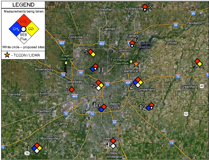
| Sites |
Installation
Date |
Latitude |
Longitude |
Measurement
Heights (m AGL) |
| Site 01 - Mooresville |
22 Sept 2010 |
39.5805N |
86.4207W |
10 / 40 / 121 |
| Site 02 - East 21st Street |
24 Sept 2010 |
39.7978N |
86.0183W |
10 / 40 / 136 |
| Site 03 - Downtown |
1 June 2012 |
39.7833N |
86.1651W |
10 / 20 / 40 / 54 |
| Site 04 - Greenwood |
8 Aug 2012 |
39.5926N |
86.1099W |
60 |
| Site 05 - West 79th Street |
30 Mar 2012 |
39.8949N |
86.2028W |
125 |
| Site 06 - Castleton |
N/A |
39.920080N |
86.027957W |
39 |
| Site 07 - Wayne Township Communications |
29 Mar 2012 |
39.7739N |
86.2724W |
58 |
| Site 08 - Noblesville | N/A |
40.041127N |
85.973403W |
41 |
| Site 09 - Greenfield |
30 Mar 2012 |
39.8627N | 85.7448W | 10 / 40 / 70 / 130 |
| Site 10 - Garfield Park |
28 Mar 2012 |
39.7181N |
86.1436W |
40 |
| Site 11 - Butler University |
N/A |
39.840264N |
86.176264W |
10 / 40 / 70 / 130 |
|
Site 12 |
Aug 2012 - Apr 2013 |
39.763703N |
86.040339
|
40 |
|
Site 13 - Pleasant View |
N/A |
39.717322N |
85.941651W
|
87 |
Independent verification of anthropogenic greenhouse gas emissions is an emerging need as legislation to
regulate greenhouse gas emissions becomes increasingly likely.
However, relatively few atmospheric measurements have been
attempted at the urban scale. The INdianapolis FLUX (INFLUX)
project addresses this need, using continuous and intermittent
tower-based measurements, aircraft measurements, urban-scale flux
modeling, and bottow-up flux modeling.
What Can We Learn?
Objective: To develop and
assess methods of quantifying greenhouse gas emissions at the
urban scale, using Indianapolis as the test site.
Project Goals:
What is Being (or will be)
Measured?
Penn State University:
Currently CO2 & H20 are measured
continuously at two sites. These sites will be upgraded to measure
continuous CO2, CO, CH4, and H20.
Three
additional
sites will measure CO2, CO, and H20, and another
three will measure CO2, CH4, and H20.
Four sites will measure CO2 & H20.
Wavelength-scanned cavity ringdown spectroscopy (Picarro, Inc.) is
used. These data will be posted on this website.
NOAA:
Flasks, filled preferentially when the wind direction is such that
Site 2 is downwind of Site 1, measure the following: CO2,
CO, CH4, 14CO2, 13CO2,
N2O, SF6, H2, and a
suite of halocarbons and hydrocarbons.
Purdue University:
ALAR
aircraft
flights,
beginning
in
Fall
2010,
will
measure CO2, CH4, and H20 continuously, as well as sampling flasks
and measuring meteorological data. Two types of flights will be
utilized: mass balance and source characterization.